Brazil leads Amazon in forest loss this year, Indigenous and protected areas hold out
Satellite imagery brings us a first look at this year’s deforestation hotspots, areas where forest cover was lost in high densities across the Amazon, amounting to more than 860,000 hectares
Publicado 13/10/2021
A first look at this year’s deforestation hotspots across the Amazon shows that Brazil, once again, has the grim distinction of being a leader in destruction. Massive areas of forest loss in Brazil cluster around major road networks, and many of these areas also burned this year.
According to a recent report from Amazon Conservation’s Monitoring of the Andean Amazon Project (MAAP), more than 860,000 hectares (2.1 million acres) of primary forest was lost across the Amazon this year — an area about seven times as big as the city of Los Angeles. The findings show that the majority of forest loss was concentrated in Brazil (79%), followed by Peru (7%) and Colombia (6%).
MAAP located areas of high-density forest cover loss for the year through Sept. 18 using analyses of primary forest loss alerts (GLAD+) produced by the University of Maryland. Alerts are detected by the Sentinel-2 satellite, which captures imagery of Earth at a 10-meter (33-foot) resolution.
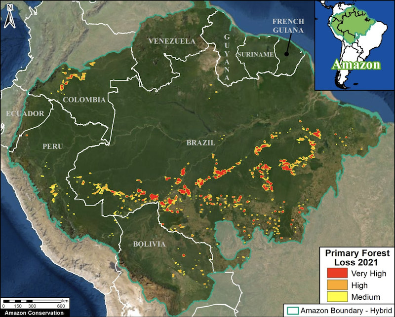
A bird’s-eye view of deforestation confirms a well-known pattern: deforestation is concentrated around roads. Nearly 95% of deforestation in the Amazon can be found within a 5.5-kilometer (3.4-mile) radius of roads or river, and 90% of fires have burned within 4 km (2.5 mi) of illegal roads built through the forest, according to recent studies.
Roads have benefits, such as granting rural communities access to health facilities and economic opportunities. But the trouble with roads is that they also pave the way for more destructive activities, allowing access for loggers, miners and land speculators, who transform the relatively small line of deforestation caused by a road into an amoeboid-like growth of forest destruction.
Brazil is a hotspot for hotspots
The major highways in Brazil built the foundation for the infamous “arc of deforestation,” the advancing agricultural frontier across the states of Pará, Mato Grosso and Rondônia, which are among the leading states for forest loss in the Amazon.
This year in Brazil, deforestation alerts show forest loss clustering around federal highways BR-163, BR-230, BR-319 and BR-364.

BR-230, also known as the Trans-Amazonian Highway, slices east to west across the widest part of Brazil. In Campos Amazônicos National Park, which sits next to this highway, more than 3,500 deforestation alerts were confirmed in primary rainforest between January and early September of this year alone, according to satellite datafrom the University of Maryland. This represents a 37% increase over the average yearly loss per year since 2017.
“It’s an area that is really important for conservation,” Fernanda Meirelles, coordinator at Idesam, a nonprofit in Amazonas state focused on conservation and sustainable development of the Amazon, told Mongabay. “The diversity is really rich, there are species that are only found there.”

Land grabbers, or those making illegitimate land claims, have driven much of the recent deforestation in the forests of Campos Amazônicos National Park, as reportedby Mongabay last month. Settlers clear and occupy land in hopes that it will lose protected status or that they will be granted amnesty — a practice not uncommon under current President Jair Bolsonaro’s loosened environmental regulations.
Since Bolsonaro came to office at the start of 2019, deforestation and fires have soared. Between January and July of this year, deforestation rose to its highest levelsince 2012. Though deforestation levels fell slightly in August, they remain almost twice as high as 2018 levels, prior to Bolsonaro’s term.
“The great jump in deforestation [in 2019] can be attributed to both the rhetoric and to the actual measures of the Bolsonaro administration,” Philip M. Fearnside, a research professor in the department of environmental dynamics at the National Institute of Amazonian Research (INPA) in Amazonas, told Mongabay in an email.
Fearnside also notes that southern Amazonas state has become a big hotspot this year, making it the state with the highest percentage increase of deforestation. But Pará state still rules in total deforestation, with almost twice as much forest area lost as all the other Amazon countries combined: the state lost 15.5 million hectares (38.3 million acres) of natural vegetation from 1985 to 2020 — an area half the size of Poland — while the total accumulated in neighboring countries amounted to about 8 million hectares (19.8 million acres), according to data released on Sept. 30 by MapBiomas, a platform that tracks the changes in land use in Brazil.
Many of the areas deforested this year in Brazil have also burned, according to MAAP. In the Amazon, forests are often cut down in the wet season and left until the dry season when they are then set ablaze to clear the land for pasture.
As of Oct. 3, MAAP reports 1,674 major fires burned in the Brazilian Amazon this year, covering 501,200 hectares (1.24 million acres) — an area about three times the size of London.

Hotspots in Colombia
Colombia also has an arc of deforestation, a frontier of forest loss across the northwestern Colombian Amazon. Satellite imagery reveals forest loss hotspots this year in and around numerous protected areas including Tinigua and Chiribiquete national parks, as well as Indigenous reserves, particularly Yari-Yaguara II and Nukak Maku.
In May, Mongabay Latam reported that Colombia’s Tinigua National Natural Park accounts for one of the highest levels of deforestation of any such protected area in the country, and has lost more than a quarter of its primary forest since 2002.
At the time, Rodrigo Botero, director of the Foundation for Conservation and Sustainable Development (FCDS), told Mongabay that more than 500 families have settled in Tinigua and are responsible for most of the recent deforestation, especially south of the Guayabero River.
“The park is already severely affected; new roads and farms have been built and cattle are being brought in,” Botero told Mongabay Latam. Tinigua lost around 25% of its primary forest between 2002 and 2020, according to data from the University of Maryland.

Waves of settlers are also deforesting the Yaguará Indigenous Territory, according to Botero, who also says road building and land clearing surged under weakened law enforcement during the COVID-19 pandemic.
“We are seeing large-scale colonization, with a lot of money behind it, being carried out at an unstoppable speed,” Botero said. “Colombia stands out because road density in the Amazon region is the highest among all the countries that share the biome. This gives an idea of the intensity of the transformation.”
“I’m shocked that this machinery [for opening roads] passes through the middle of reservations, national parks and forest reserves,” Botero added. “It does so with or without the presence of [FARC] dissidents, with or without the army. It’s out of control. There are new roads in the most unexpected places.”

Hotspots in Peru
A map of Peru shows deforestation concentrated in the central Peruvian Amazon, namely the Ucayali, Huanuco and southern Loreto regions. Nearly 300 hectares (741 acres) were cleared for the creation of a new Mennonite colony and 382 hectares (944 acres) for a large-scale rice plantation, MAAP reports.


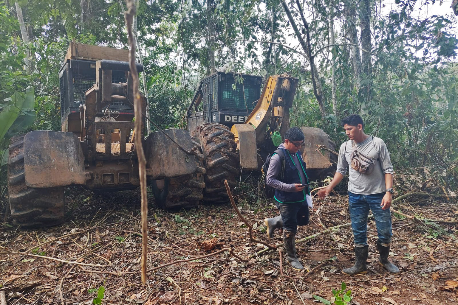
Loggers in the Ucayali region of Peru have illegally opened up an abandoned road. The road, UC-105, goes through the Sawawo Indigenous Reserve near the Brazilian border and threatens other Indigenous territories. Reopening the road was not authorized by the government, and critics warn it will bring deforestation, drug trafficking and river degradation into the region.
“There is no oversight, there is no control,” Francisco Piyãko, an Ashaninka Indigenous leader from the Kampa do Rio Amônia/Apiwtxa reserve, told Mongabay last month. “It’s a calamity.
“They are already moving ahead with this destruction without any participation from the Indigenous communities,” Piyãko said. “This road is completely outside legality.”
Some additional deforestation hotspots in Peru are noted in the Madre de Dios region in the south and attributed to gold mining and medium-scale agriculture. The cleared patch in the northern Loreto region is due to natural forest loss from a wind storm, according to MAAP.
A way forward in a changing Amazon
Although the Amazon as a whole remains a carbon sink, two recent studies have concluded that the Brazilian Amazon is emitting more carbon than it absorbs, with increased deforestation and fires largely to blame.
MAAP documented the loss of more than2 million hectares (4.9 million acres) of primary forests across the western Amazon between 2017 and 2020, with the highest loss in 2020 (588,191 hectares, or 1.45 million acres).
Of this, only 9% reportedly occurred in protected areas and 15% in Indigenous territories. Most took place outside these key land use designations — highlighting the importance of protected areas and Indigenous territories and the recognition of Indigenous land tenure for safeguarding the remaining Amazon rainforest.
“As deforestation continues to threaten primary forest across the Amazon,” MAAP writes in the findings released in July, “key land use designations are one of the best hopes for the long-term conservation of critical remaining intact forests.”
Citations: